Pere Marquette River – A popular destination for paddlers and salmon


While most use the river for day trips, with 56 miles of navigable water, it also offers opportunities for two- or three-day excursions.
By Dave Foley
A long-time favorite of Michigan paddlers and fishermen, it may be hard to find solitude on the Pere Marquette River during the summer boating season and prime fishing times in the spring and fall when thousands of spawning salmon, steelhead and brown trout head upstream from Lake Michigan.
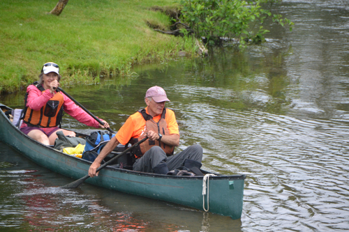
Today, crowds won’t be a problem. On this June morning as we drive into the DNR Canoe Access south of the village of Baldwin off M37, we’re the first car in the lot, but at the other end there’s a guy unloading two trailers of canoes. In a few hours there will be a flotilla heading downstream, but our early start will put us ahead of the crowd.
Although it’s less than fifty miles from our home, I’ve only explored short stretches of this river. Today Cyndy and I have packed our camping gear and the plan is to take our canoe 45 miles downstream to Scottville where we’ve spotted a car.
Here in the upper reaches, the stream is about fifty feet wide and the current is swift, often flowing over gravel and sand, but even novice paddlers should be able to keep from tipping. Basic turning skills are needed, however, as this is a river of a thousand bends. That’s ideal trout habitat as most of these turns are filled with snags and fallen trees, but maybe not so good for paddlers who haven’t mastered the proper execution of the rudder and draw strokes.
Today, we have the river to ourselves. The only others moving downstream are blue herons, first appearing ahead of us, standing like statues, apparently hoping we won’t see them. Then, as we get nearer, these long-necked birds take flight, long wing strokes lifting them up and carrying them down around a bend. A minute later, we’ll see them again as they take off on another downstream flight. We might follow the same heron for a quarter hour before it finally figures out it can fly back upstream and get away from us. Invariably, within a few minutes we spook another heron and the pursuit starts all over again.
More deer are out on the river than fishermen. After seeing an angler walking along the bank, we suddenly hear a massive splash, like a body falling into the river. We look up, expecting to see the fishermen floundering in the water, instead a deer emerges swimming toward the opposite shore. Rounding the point of land, we see a fawn peering over the grass tops. The man also notices the tiny animal, and turns and walks away so not to further frighten the fawn. We paddle on, leaving the doe to reunite with her baby.
Although we see some cottages, much of the riverbank is heavily forested with cedar, pine, maple and oak trees. It’s likely to stay that way as the Pere Marquette River is designated a Scenic River by the National Wild and Scenic Rivers Program. We stop to snack and stretch our legs at Gleason’s Landing and again at the Bowman Bridge camping area, two popular day trip destinations for canoers.
Near Sulak Landing, I see a couple steelhead slide into holes as we pass by. Though I’m not fishing today, I’ve got my eyes in the river and catch glimpses of a few suckers and small trout that scatter as we approach.
The most challenging section of the river comes shortly after Rainbow Rapids Landing. Here we encounter a stretch of white-tipped fast water. Though it looks daunting, some deft steering by Cyndy and a couple quick pry strokes I throw in from the bow gets us easily through it. Anyone with a little canoeing experience will have no trouble here.
About five minutes past Upper Branch Bridge, we see a sign saying ”Elk,” the indicator of a small camping area with no road access created for use by overnight paddlers. Although we’re the only human campers, hordes of mosquitoes have already laid claim to the site. A layer of insect repellent holds these winged biters at bay so we can pitch our tent, cook dinner and sit by the river as night falls.
By nine the next morning we’re heading downriver again. This is our favorite time to travel, the recreational paddlers and boaters are nowhere to be seen, and the air is filled with songs of birds. Someday I’d like to be able to identify the calls coming from these feathered creatures, but today, with the exception of crows, blue jays, robins, geese and doves, the makers of these calls remain anonymous. We surprise several deer coming to the river to drink. At our approach they bolt back into the forest.
The river has doubled in size since we started our trip. There’s no more worries of grounding out on gravel bars. The current is steady and strong making it look like today’s run will be easy, but there are surprises in store for us.
Below the Walhalla Bridge, we enter marshy lowland and the river divides into various channels. This is known as the “spreads.” Every few minutes two or three strands of river branch off and we have to make a choice. Usually only one will offer clear passage. Make a false choice and the stream may dead end, shrivel to inches deep or the open flow may be cut off by fallen trees. Once we guess wrong and have to get out and pull our canoe over sand flats. Our most harrowing moment doesn’t come in a meandering river channel, but instead from a man made hazard, Indian Bridge.
We assume every bridge will have enough height for canoes to have clear passage under them, but higher water resulting from recent rains makes that a false assumption. As we glide toward the bridge I suddenly realize that we may not have enough room to fit under the span. “Duck” I yell as I dive to the bottom of the canoe. Behind me I hear, “Oh no,” and some thumping as Cyndy drops to the floor. We clear the bridge by inches and as we come out from under it, I look back to see what Cyndy’s concern was. The handle on our cooler, which is jammed in the upright position, apparently barely missed clipping the bridge support.
Below Indian Bridge there’s few more sections of the spreads to navigate, before the river comes together and leads to Scottville, where we end our trip.
Info:
Though we never saw another canoe or kayak during our two-day, 45-mile trip downriver, on summer weekends and during the spring and fall runs of steelhead and salmon, the Pere Marquette can become congested. For this reason the U.S. Forest Service requires that anyone who launches or retrieves a boat on National Forest land must have a permit. Permits, which are required from mid-May until early September, cost $2 per watercraft per day. Because there is a quota of permits issued for every day, those looking to paddle on summer weekends when demand is high should consider obtaining permits several months early. Between May and September, canoes and kayaks can only be on the river between 9 a.m. and 6 p.m. Permits may be purchased online at www.recreation.gov .


