Circling Rhinelander by canoe …
PADDLING
BY PETER NORDGREN
For a long time I’d looked at the map – for decades, in fact. There was something unique there.
One of the attractions of well-known canoe territories like the Boundary Waters Canoe Area (BWCA) and Sylvania Wilderness is their circle routes. You can launch from a landing, travel and explore several days and return to the start without backtracking. Circle routes, however, are rare in the US outside the national and state forests. But I’d seen a possibility on the map, back when I lived in the Rhinelander area in the 1980s. The time had come to find out if it was feasible.
Looking at the map, I could launch at the mouth of the Pelican River where it enters the Wisconsin River on Rhinelander’s southwest side. Next would be a short paddle upstream on the Wisconsin, then a portage around the paper-mill dam. I could cross Boom Lake and Thunder Lake, which are both a part of the flowage behind the dam. I’d then portage to the headwaters of the Pelican’s North Branch at Shepard Lake, paddle down Shepard Lake Creek and the Moen Lake Chain. Finally, I’d ride the North Branch into the main Pelican and back to the starting point. This would be about 35 paddling miles, plus a three-mile portage.
I set out in late August of 2017. The wet summer promised sufficient water levels on the Pelican for decent canoeing. With the long carry in mind, I used a 17.5 foot Kevlar Wenonah Escape. Designed for efficient tandem-lake paddling, it wasn’t the optimum solo canoe for this combination lake-river route, but it was the lightest watercraft in my collection.
Up the Wisconsin
I launched from the Pelican Rapids boat landing in late afternoon after waiting for a rumbling weather front to pass. Pelican Rapids, incidentally, is the cataract on the Wisconsin now bypassed by the paper mill dam; it’s also the original name of the city of Rhinelander, which grew from a trading post at the landing. Paddling upstream on the Wisconsin was not difficult and I moved quickly as another storm cell rolled in from the west, bringing with it hammering rain. The Kemp Street bridge was ahead; I pulled under, waiting, sheltered in an eddy until the downpour ended. Not far upstream was the Norway Street boat landing, where I took out and portaged eight-tenths of a mile on the west side. I carried through the Ripco Credit Union parking lot, drawing amused smiles from a few employees leaving work. Then it was up the Sutliff Avenue sidewalk past the regional DNR offices and around the Expera paper mill, walking under a railroad track through a pedestrian tunnel in the process. Up a gravel alley and across Phillip Street, and I was at the put-in for Boom Lake.
Just over a mile of paddling to the north and west, I landed at city-owned Baker Island. A small campsite is tucked into the island’s stand of tall pines. The sun, having passed through the 2017 eclipse earlier in the day, treated me to a brilliant orange sky at day’s end.
Crossing the Watershed
I woke at daylight to the sound of a rising north wind, as predicted following the storm front. On the water shortly after 6:00 am, I hoped to cross Boom Lake’s most open reach before heavy waves formed.
As I moved out into the open lake, the waves were growing into whitecaps. Though I paddled kneeling at center, I soon found my long canoe was weathervaning – being turned and pushed up toward the southeast shore. I crabbed my way along to the west end of the city’s Hodag Park, slid up on the landing and considered my options.
A detour to the lee shore (to the north) would be too long. Since I couldn’t keep reliably on course, I chose to portage about a half-mile northeast on the Hodag Park paths along the lakeshore. This took me beyond the long fetch of the open lake and into a calm channel just a few hundred feet wide. I re-launched at the city swimming beach and went eastward through the more protected Thunder Lake, turning northwest to take out at County Highway W.
The takeout at the W bridge was the most difficult of the trip. There was no landing and all four corners offered a scramble over boulders. I chose the southeast corner, hoisting pack and then canoe over the rocks.
After concealing my pack in the bushes, I picked up the canoe and began the carry, turning east on Birchwood Drive. The rural road had sparse morning traffic. Soon I was walking up a small rise by one of the city water towers. This was the height of land between the Wisconsin and the Pelican. As I topped the hill, my route opened into a view of the Rhinelander Menards parking lot. I crossed the lot and headed for another feature found on few portage trails: a fully-stocked convenience store. Setting the canoe on the lawn, I re-fueled with hot coffee and a big donut.
The Pelican headwaters were only a few hundred yards away at Shepard Lake, but I’d learned there was no public access and the outflow was probably not navigable in its upper reach. I crossed Highway 17 and carried 2 miles east on Shepard Lake Road. There, Shepard Lake Creek swung next to the roadway. My GPS watch read 3.22 miles from the takeout. I left the canoe on the bank, returned to Highway W for my pack, and then crossed the carry again to the put-in. Total portaging time: 3.5 hours, including a coffee break.
Shepard Lake Creek brought memories of the BWCA’s Frost River as I wound through more than 2 miles of marshes rimmed by tamarack and spruce. A snowmobile bridge lift-over and a couple of small beaver dams were easily passed; then came the railroad bridge. Its clearance was about a foot, far too low to even slide the canoe under. Fortunately, the rusty, overgrown track indicated little chance of a train during my lift-over. A half-mile downstream, another bridge on the same track had plenty of headroom; the nearby Lakeshore Drive bridge was lower, but still passable when I lay down in the canoe.
I coasted out of the creek and into the open water of Moen Lake. The north wind chased me down the chain into Second and Third Lakes, through a 2-mile channel, and across Fourth and Fifth Lake. In late afternoon my destination of the day came into view: a state-owned island where camping is permitted, near the north shore of Fifth Lake. I raised my tent on a point of red pines, and then napped before dinner while a light rain squall pattered on the nylon.
The Wild Pelican
In the early morning sunshine I portaged North Pelican Dam on a well-marked trail. I chose the farthest downstream of several landings, avoiding a shallow rock garden just below the dam.
I wasn’t sure what to expect on the river ahead. The most detailed description I could find was from the late 1970s, in the long out-of-print Canoe Trails of Northeastern Wisconsin. There it’s termed “suitable for beginning canoeists.”
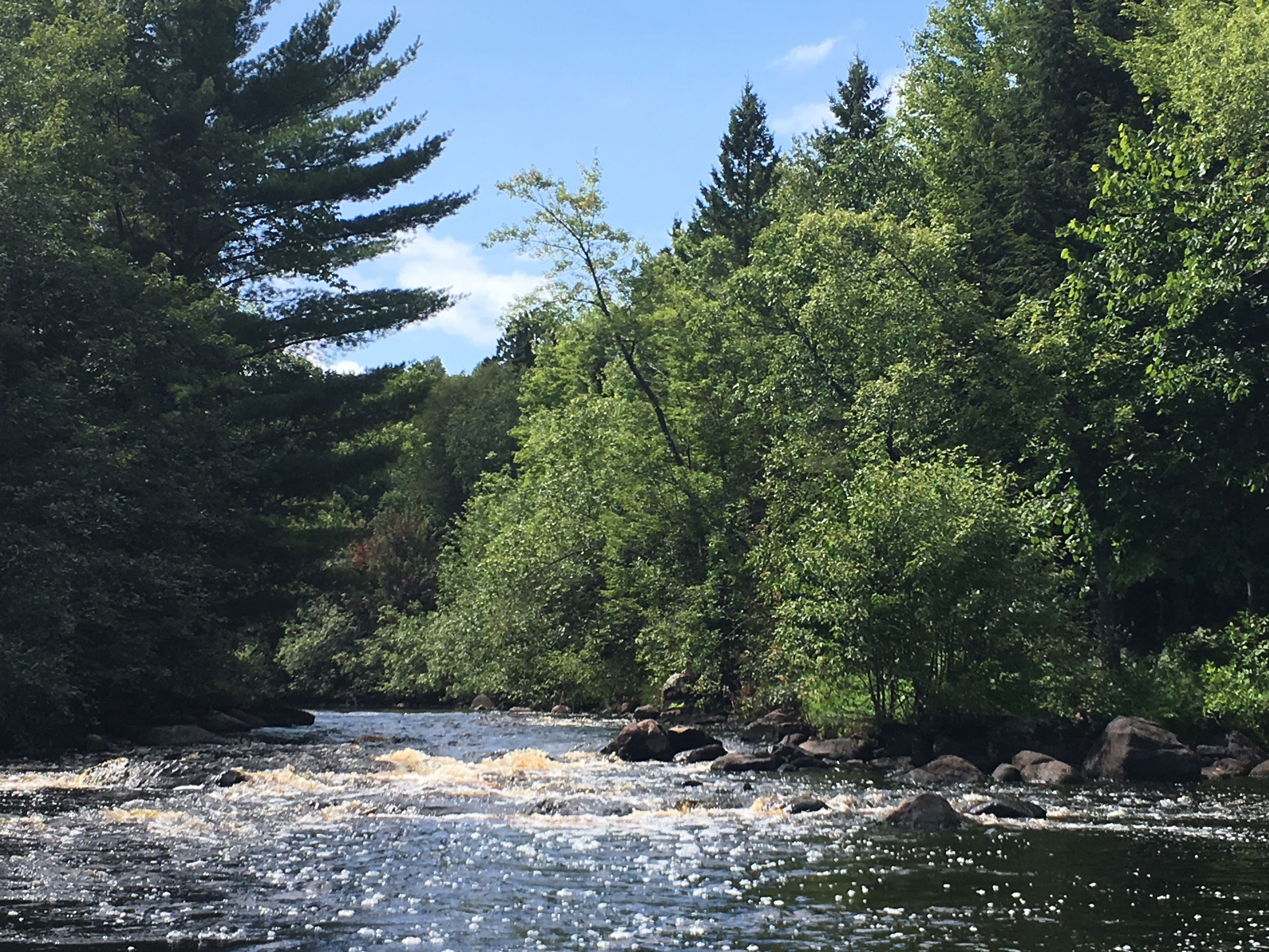
The first few miles below the Moen Chain are marshy, passing through a wide-waters called Fish Lake. Here I saw herons, ducks and a pair of trumpeter swans in the wetlands. Soon the rapids began. Three drops above the US 8 bridge were straightforward Class I – small ledges with rocky run outs. The third of these, just above the Old Highway 8 bridge, had three separate pitches.
The middle Pelican, the few miles around the junction with the main branch, wound through bottom lands of tall, arching river maple. Then outcroppings of rock, likely Penokean basalts, started to appear. Ahead were 4 miles of river featuring fairly challenging pool-and-drop boulder-garden rapids, with short breaks in between.
The Northeast Wisconsin guidebook shows two named rapids: Ryans Rapids and Devils Rapids. Ryans Rapids, about a mile above River Bend Road, may rate Class II due to higher waves and some maneuvering needed in fast water. Devils Rapids, starting a half-mile below River Bend Road with three pitches, finished in a rocky run out with no real options to avoid the boulders, which brought to mind the Bois Brule at the head of Big Lake. Around these rapids are eight other drops, most Class I, but two nudging Class II due to the challenge of finding rock-free routes.
After pushing over the rocks at the foot of Devils Rapids, I paddled 5 miles of quiet water back to the Wisconsin and my waiting vehicle. The river roamed through dense conifer woods, then past farm fields and close to backyards on the outskirts of Rhinelander. Kids waved from their driveways. An unexpected obstacle appeared: a huge, river-spanning red pine strainer, but other paddlers had been there to saw off a few limbs, so I could drift under the gnarled trunk.
Late in the afternoon of the sunny, warm day, I returned to the landing where I began 48 hours earlier.
Completing the Circle
The Pelican is no beginner’s river, but it’s a challenge to test the skills of intermediate paddlers. People in the area do canoe it regularly, especially the section from US Highway 8 to River Bend Road, containing most of the rapids.
This easily-accessed route is not remote, but passes through wild country on Shepard Lake Creek, parts of the Moen Lake Chain, the North Branch of the Pelican and a few miles of the Pelican’s main branch. There’s plenty of classic Northwood’s scenery to savor.
Despite starting and finishing in the city, I met just a few people on the trip. While portaging the roads, a guy in a rusty pickup pulled up.
“Are you doing OK?” he asked.
“I’m doing OK!” I said from under the portage yoke.
He grinned and drove on. Then there was the young boy fishing at the Boom Lake Dam. He asked how far I was going – about 40 miles, I replied.
“Gee! Are you doing this just for fun?” he asked.
“Yes,” I said. “I’m doing it just for fun.”
And it was.