Lake Huron’s Philip Edward Island
Exploring with Polly Scotland
The foghorn sounds its low groan every few seconds.
Four kayaks eerily appear from the fog and glide into Chikanishing boat access. A brunette ponytailed woman slides out of her vessel and shouts, “Hurray! We’re back alive!”
My husband Lee and I look up from stowing our gear into our tandem kayak for our five-day trip to Philip Edward Island (PhEI) off the coast of Killarney Provincial Park in Ontario, Canada.
I help the age-20-something girl pull out her kayak and ask, “Are you okay?”
“Yeah. But a bear found our food bag in the middle of the day,” she explains holding a red nylon bag that is shredded.
The girl’s boyfriend adds, “It was a cub, but when I looked closer at a picture I took, I could see Mama hiding in the dark shadow.”
The other boy pulls out his map and says, “This is where the bears are. Also, use your compass. We took a wrong turn in the fog and went 30 minutes out of our way.”
“Thanks,” we say and shove off into the fog to circumnavigate an island.

Leaving Chikanishing River with fog draping the surroundings. Polly Scotland photo
Two billion years ago, grinding glaciers and fiery volcanoes left the Killarney area with the white quartzite La Cloche Mountains (now hill-sized) and a batholith of pink quartz rock in Georgian Bay.
In the mid-1850s, two British surveyors Captain Owen and Lieutenant Bayfield named Lake Huron’s largest bay for King George IV. Bayfield rewarded his assistant, Phillip Edward Collins, by naming both an island and an inlet after him. Philip Edward Island is one of thousands of islands in Lake Huron’s Georgian Bay. Shaped like a straight-backed mythological turtle with multiple feet, this island is east of the town of Killarney and west of the French River.
We leave the safety of Chikanishing River and cross the open water of the western entrance to Georgian Bay – considered by some to be a sixth Great Lake – to South Point Island.
A motorboat with two people holding another boat to its starboard side materializes from the fog. A short distance behind them is a third boat with four people in what seems to be a rescue mission. They are intent on getting to the mainland.
At Rattle Island, we eat lunch hoping the fog will dissipate. We sit on red gneiss (pronounced nice) rock next to a bed of fragrant wild roses and juniper bushes. After an hour Lee says, “We didn’t drive all this way to not see the rugged coastline. Let’s travel clockwise and paddle Collins Inlet first.”
A cruising motorboat interrupts the sound of water dripping from my paddles. For hundreds of years, Collins Inlet was a safe passage from the open waters of Georgian Bay for the First Nation people as well as European fur traders, loggers, miners and fishermen. Today this 12-mile-long channel is primarily used for tourism.
The sun breaks though and illuminates purple irises and white and yellow water lilies dotting the coastline of the inlet. Beaver houses hug the shoreline every mile. The first row of alder brush is dead due to the unusually high water. There are old iron rings from the logging days embedded in rock.
We spend our first night in Mill Lake, which is a widening of the long, narrow Collins Inlet. After checking out three potential campsites, we settle in at Racing Island. A lone yacht moors across the channel.

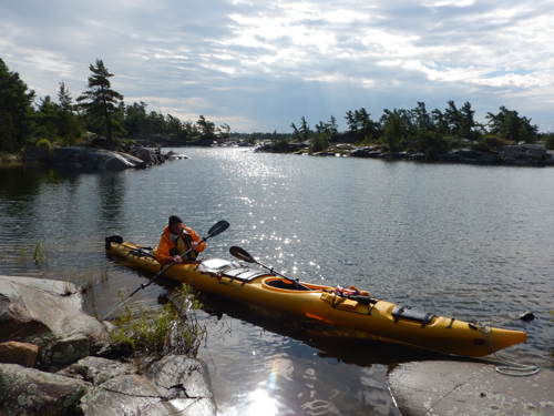
Lee Scotland checks out the surroundings while on Rattle Island. Polly Scotland photo
Lee builds a fire in the stone ring. As he cooks potatoes, corn on the cob and bratwurst over the amber coals, we sip on Merlot boxed wine.
The sound of a motor grows louder as the yacht’s zodiac approaches us. We go to greet the couple and as I say,
“Hello,” the couple’s large poodle leaps to shore and runs all over our island.
Thinking the couple has come to socialize, I ask, “Where are you folks from?”
The man says, “We’re from New York. We’re taking a year to do the Great Loop tour through the Great Lakes, down the Mississippi, then up the Gulf and Atlantic waterways.”
The woman notices that I am watching their dog sniff our stuff and she says, “This island is our dog’s spot. It’s her favorite.”
I look at all the surrounding islands and think, “Really? The dog has to use ours?”
I turn back to the couple as their dog jumps back in the zodiac and they motor away. The woman calls over her shoulder, “See you in the morning.”
Lee looks at me and says, “What the hell?”
True to their word, the man brings the dog back; fortunately most of our gear is packed and ready for Day Two.
We continue east before rounding the bend into Beaverstone Bay. A man sitting on a point waves us over.
He shouts, “Have you ever been here before? Do you have a forecast?”
Lee tells him, “This is our first time. The marine radio predicts east winds up to 15 knots with rain in the afternoon.”
Clearly, he is agitated and the man presses, “Do you think we can make it to the French River?”
Lee can’t judge the man’s skills, but tries to assure him, “You can probably hide behind the multiple islands in Beaverstone Bay before making a decision about entering the open waters of Georgian Bay. But only do whatever makes you comfortable.”
I wish him luck as I pop open my umbrella for a smooth and unique sail to the conglomeration of Dussin Islands. The map doesn’t clearly mark designated campsites, but after inspecting a few, we set up quickly as the clouds grow ominous.
The predicted rain strikes, so we are forced to assemble the tent under our tarp. The same menu as the first night is prepared and consumed. When the nightly onslaught of mosquitos arrives, I dash into my slightly damp sleeping bag.
In the morning, I discover several slimy slugs residing on our tent. I pick them off and listen to the distinctive squawks of the sandhill crane. A mink swims back and forth between rock outcroppings, keeping us entertained during our morning breakfast of eggs and cheese on tortillas.
We turn east out of Beaverstone Bay to explore The Chickens. The largest island in this archipelago group is called Hen Island with multiple “eggs” scattered about this two-mile section of Georgian Bay. Three miles further to the east is the Voyageur Channel entrance to French River and eventually on to the Saint Lawrence Seaway, but we don’t have time on this trip, so we turn west to explore the south shore of PhEI.
We encounter several groups of 10 to 12 kayaks – mostly young teenagers being guided by two leaders. One group from Shelby, Michigan’s Camp Minniwaken is on a 21-day trip to Snug Harbor, Ontario.
We paddle over the white streaks of shoals too dangerous for any vessels to traverse except for kayaks. A flight of black cormorants seems annoyed when we interrupt their voracious eating schedule. Mama merganser skims the water leading her little ones toward the protection of hidden cracks in the rock.
Our third night is on an island in Bear Bay. Curled up on the hot rock at the landing’s approach is a snake.
Disguised as the dreaded rattlesnake, this northern water snake is a master of deception, taking advantage of its gray-brown color design to scare the daylights out of me.

This northern water snake suns itself on a rock. Polly Scotland photo
Other than the snake, this island has everything we want: flat tent site, firewood, good cooking area, sunshine to dry our equipment and a great view.
I stand beside a campfire and watch the wind switch, creating white caps over the shoals of the expansive bay. I am smug in my raincoat and pants knowing that mosquitoes can’t penetrate it. That smugness is short lived.
At 4:00 a.m., the light pitter-patter of rain falls on our tent. I debate if I can make another two hours before having to tend to a call from Mother Nature. I know I will sleep better if I can relieve myself.
I grab my umbrella, unzip the tent, and head out. Hundreds of mosquitos are excited. I can’t re-zip the tent fast enough, letting lots of those ferocious insects in. I pop open the umbrella, which now acts as a catchall for hundreds of ecstatic bloodsuckers. I continuously swear and swat my exposed body as I try to relax enough to go. The bugs are in a feeding frenzy and I am losing the battle.
For the next five minutes, Lee and I wipe out the swarm of those hellish creatures that follow me back in. Lee puts his head net back on, rolls over, and falls asleep. I am wide-awake as the rain stops.
In the morning, I feel the hard welts of the no-see-ums that attacked me as well.
After breakfast of the fourth morning, we wander behind the bigger islands, where a maze of reeds and swamps make navigation interesting. The great blue herons screech. The threatened yellow-throated Blanding turtle rests on a log.
The panorama from the top of Jill Island includes the Cloche Cliffs and Manitoulin Island, the world’s largest fresh water island. I marvel at the geology of Killarney’s Precambrian Shield. Windswept trees are bent at the top third of their trunk.

Lee Scotland keeps the tandem kayak close to the embankment on Dustin Island. Polly Scotland photo
Standing in my wetsuit, I cool down, so I descend back down the humpbacked rock to the kayak. Lee says, “We’re less than two miles from the car. Let’s finish the trip early before the next rain.”
We return to the Chikanishing parking lot that is jammed with kayakers preparing to go out for the weekend and day hikers trekking a 1.5-mile loop. I enjoy listening to a mother and her three daughters trying to discern what items will be needed. I wonder about another group that is stowing 36 plastic water bottles for a trip on a Great Lake.
After we load our car, we drive to the quaint fishing town of Killarney at the end of Route #637. Following a coin-operated shower at the marina, we enjoy a fresh fish and chips dinner at Herbert’s Fisheries. Twenty-five years ago we sailed with our kids to Herbert’s. Their famous red and white school bus has been moved and the restaurant is modernized, but the daily-caught fish is still outstanding.
After dinner, we stroll along Killarney Channel, listen to the gulls, see the trawlers unload their catches, smell the fishy air, and overhear snippets of revelers’ conversations.
I appreciate this land that was scrubbed by glaciers and polished by ice and rain. With the safety of the batholith islands to hide behind, Philip Edward Island of the Killarney area is a kayaker’s mecca.