NW Michigan bike trails among the best in the Midwest – Part I. Oh, What the Heck! Part II (September Issue) as Well!
By Dave Foley
[Please add your thoughts by scrolling way (way) down to the comments box. Thank you!]
(Click on photos below to enlarge)
Finding trails designed for mountain and fat biking in northwest Michigan will never a problem. What may prove tough, though, is choosing among so many great options. You could go on a different trail every day, week after week, and all your rides would be first-rate. Part I of this feature presents four of the best-known trails. [Editor’s Note: And Part II also follows].
Cadillac Pathway

The 11-mile loop of the Cadillac Pathway is used by skiers and bikers. Photo by Dave Foley
In the 1980s, I did my first mountain bike riding on the Cadillac Pathway Trail. That original 11½-mile trail still gets year-round use: as a groomed ski trail, then giving way to bikers, runners, and hikers. Over time, single-track loops have been added.

More than 300 bikers race the Bearclaw Epic on the Cadillac Pathway. Photo by Dave Foley
You will find the Pathway located about 3 miles east of Cadillac, MI. Most access it from the north end off Seeley Road. Here you will find an outhouse, pavilion, fireplace, bike/ski rack, bike fix-it station, and a parking lot big enough to handle this trailhead’s increasing popularity. The loops at this end ride generally quite flat. The southern half of the trail system has more hills and most of the single track.
In 2017, an eleven-mile winter sports trail was added dedicated to fat-biking and snowshoeing. The Winter Sports trail, a seasonal trail, stays available only from December through March. A snowmobile and groomer were purchased, and a team of volunteers packs the trail after every snowfall. With the Michigan DNR’s assistance, plans have been made to add an additional eleven miles to the trail system.
In late September, the Pathway becomes the site of the Bear Claw Epic Mountain Bike Race (www.bearclawepic.com). Heading into its 6th year, the Bear Claw draws over three hundred riders. All proceeds go to the maintenance, development, and improvement of the Cadillac Pathway.
Big M and the Udell Hills
Originally a National Forest downhill ski venue in the 1960s, Big M has since become a destination for mountain and fat bike riders. Located about halfway between Cadillac and Manistee, the recreation area spreads south of M55 off Udell Hills Road. During winter, an 18-mile network of trails are groomed for cross-country skiers. The remaining 15 miles get packed for fat bike riders.

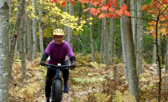
Riders on Michigan trails will be treated to a spectacular color show in late September through October. Photo by Dave Foley
Before the fat bike trail system’s development, the ski trails received plenty of use by mountain bikers. The trails span wider than single-track, suitable for novice bikers with two exceptions—the Oh Me II and the Catamount loops lend themselves better for experts only. Their steep climbs and rapid descents may be more than average cyclists should attempt.
Last fall, I spent an afternoon exploring Big M’s single-track loops. Entering off the Corkscrew loop, I soon encountered a long, grueling climb. It proved itself the toughest hill on the loop. Shortly after that, a downhill’s steep drop and hard-left turn spooked me, a descent for expert riders. I opted to walk. From then on, through most of the fifteen-mile outer loop, the riding became easy.
If you begin the trail on the north end of the parking lot, the 6 and 9-mile loops starting there rate easy or moderate. They can be ridden without trepidation by most bikers. The North Country Trail crosses the Big M trails at two points. The NCT has been marked with blue markers.
In addition to a popular ultra-distance trail run, Big M hosts two bike competitions. In March, the Big M Fire Tower Fat Bike Race features a 6-mile, fairly flat loop, and a more difficult 16-mile circuit. On the third Saturday in June, the Big M hosts the Lumberjack 100, an ultra-endurance mountain bike race (lumberjack100.com). Capped at 430 racers, selling out in under an hour in 2019, the Lumberjack 100 is part of the National Ultra Endurance Series. Three laps of a 33.33-mile course, gives riders over 9000 feet of climbing.
Crystal Mountain Resort
For most recreational enthusiasts, Crystal Mountain Resort conjures up thoughts of downhill or cross-country skiing. Or perhaps the staging area of the Peak2Peak Mountain Bike Classic. Less known is that the resort has a first-rate experience awaiting mountain and fat bike riders.
During my recent stay at the Thompsonville Resort, attending the Michigan Outdoors Writers’ Association Conference, I explored this trail system after picking up a map at their bike center. Known as the Mountain Adventure Zone, there you can rent bikes and helmets, as well get lessons, or hire a guide to take you on the trails.
You face no charge for riding the trails in summertime, except for bikers using the chairlift to access Gravity Park. After paying a $20 fee, cyclists take the chairlift with their bikes attached and pedal down. These are black diamond runs with starting points for trails named Screaming Eagle, Crystal Climb, and Peak2Crystal. Being best left to expert riders, I wasn’t going to experience these firsthand.
The first part of my ride covered the paved Crystal Mountain Drive, passing condos and the golf course before leaving the road to enter the Aspen Trail, which stays relatively level throughout its four-mile length. A packed-dirt path, the main trail, proves wide enough to prevent handle bars from clipping a tree. A left turn led to the Pineapple Loops, a group of pancake-flat circuits.
At a junction, a sign points to an option labeled “Aspen Tech Trail.” This trail can provide for those wanting to test themselves a bit. Some tight turns and a couple quick drops and climbs. Nothing too hard for an intermediate rider, and it goes for only about three-tenths of a mile. A little farther up the trail, an intersection gives riders the option of staying on the main trail or taking a side trail labeled “Aspen Singletrack.” The side trail narrows and becomes a series of tight squiggles, so keep your eyes focused on the trail as trees crowd closer to the path.
At the end of Aspen, you can loop back until reaching the Betsie River Pathway. This portion of the trail is part of the Pere Marquette Forest. Here, a series of looping options await you, with the farthest north bringing riders to the Betsie River. Between this and the Crystal Mountain trails, between 14 to 16 miles of marked pathway give plenty of riding. Numerous two-tracks and forest trails provide an infinite number of ways to configure a ride. You’ll also find good signage with maps and numbered posts to keep you oriented.
Make sure you note a phone number on the map (231-378-2238). In case of injury or mechanical failure, you can call that number to reach the resort’s recreation office for help.
In winter, trails are groomed for fat biking. Folks can bring their own bikes or the resort offers rentals. A ten-dollar trail-usage fee offsets the cost of winter grooming.
Arcadia Dunes
About 20 miles southwest of Traverse City, just north of the village of Arcadia, the Arcadia Dunes Trail System can be accessed off St. Pierre Road. Riders will find the trail tight and technical, and the 10-mile loop, with about 1000 feet of climbing, is considered more challenging. While the climbs may be tough, the downhills are either exhilarating or scary, depending on your skill level. Often described as having trails that are “smooth and flowy,” Arcadia Dunes has a 4-mile loop that may be more appealing to less-experienced riders.
A few years ago, the Grand Traverse Regional Land Conservancy partnered with the International Mountain Biking Association to create this trail system.
From the September Issue
Part II covers four other top-tier rides: Hanson Hills, VASA, Glacial Hills, and Palmer Woods trail systems.
NW Michigan’s Favorite Mountain/Fatbike Bike Trails – Part 2
Also by Dave Foley
Last month, I talked about Crystal Mountain, the Big M, the Cadillac Pathway, and the Arcadia Dunes Trails, all popular biking destinations in the northwest part of Michigan’s Lower Peninsula. In this feature, we’ll look at look at four more favorites of trail riders.
The VASA
South of the Mackinac Bridge, there’s no more popular trail system than the VASA. Located east of Traverse City are three trailheads.

Riders on trails like the VASA will be treated to a spectacular color show in late September and throughout October. Photo by Dave Foley.
Bartlett Road and Timber Ridge get most use by cross country skiers, while mountain and fatbike enthusiasts favor the Supply Road start point. The ski trails provide a series of loops (3K, 5K, 10K, and 25K) offering challenges from easy to difficult. These trails, which are wide enough to accommodate giant trail grooming machines, get some biker use, but riders opt for the 18 miles of singletrack trail.
In winter, using the groomed ski trail for biking is discouraged unless riders are on low pressure tires. The singletrack trail is much less challenging than the ski trail. With a few exceptions where the trail provides a couple steep drops and mild climbs, the singletrack trail works well for beginning cyclists. In winter, the Supply Road start is often nearly filled with cars. The grooming team tries to get on the trail soon after every significant snowfall to keep it open for fatbikers.
The VASA Skillz Building Loop, which opened in the summer of 2019, has been specially designed for kids and adults new to mountain biking. Two one-mile, single-track loops have been completed and feature elements such as jumps, tabletops, berms, and rock gardens to help people advance their mountain biking skills. The more technical sections of the trail provide ride-arounds for less experienced riders. This pathway will be expanded to include more skill-building challenges.
On the first Saturday of November, over 5,000 riders from across the country and all parts of the world ride the 30-Mile Iceman Challenge, which uses sections of the VASA course and finishes at Timber Ridge.
Palmer Woods

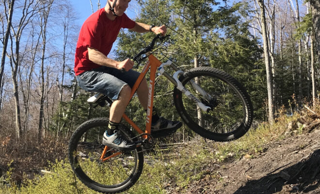
Like to do jumps? Like Dave Foley’s airborne son-in-law, Ben Boyce, you will find a few on the Palmer Woods Pathway. Photo by Betsy Boyce.
While the VASA singletrack is user-friendly for the novice, the Palmer Woods Forest Preserve Trails have been developed for experts.

Riders at Palmer Woods will find plenty of challenges. Photo by Betsy Boyce.
First opened in November of 2018, this venue is a work in progress, with about 6 miles ready to ride. The trail system, located off Wheeler Road near Big Glen Lake, encompasses 721 acres and is laid out on land donated by the Leelanau Conservancy, and maintained by the Northern Michigan Mountain Bike Association (NMMB).
Palmer Woods, the first professionally designed public flow-style mountain bike trail in northwest Michigan, features tabletops, drops, berms, rollers, and jumps. The trails are two intermediate-level loops accessible for riders of all ages, with A & B lines, set up with well-marked ride-arounds.
The Central Ridge Loop features a gut-busting climb with a rewarding downhill descent featuring rollers, berms, and drops that provides a fun test for intermediate riders. The East Ridge Loop offers more challenging riding for intermediate riders, with tighter corners, steeper slopes, and most-difficult optional sections with tabletops and jumps. These challenges have labels so riders will know what they’re approaching.
When completed in 2021, the Palmer Woods Trail System will have over 9 miles of hiking and skiing trails, and over 11 miles of mountain biking trails.
Hanson Hills
Located near the village of Grayling, the Hanson Hills Recreational Area covers 1,500 acres, with more than 20 miles of trails for mountain biking broken into two, 10-mile loops with a 4-mile loop for beginners.
The first part of the trail is flat for nearly a mile. After that, you start climbing as you approach the ski hills near an area that looks like sand dunes. The trail winds through timberlands and rolling terrain. Not a great deal of technical expertise is required, but you will do some serious climbing on what is used as tubing hills in the winter.
To spice up the rides, you’ll encounter tree roots, sand, and rocks on the trail. Although a few parts follow the ski trail, much of the route is winding single track. Bikers are asked to pay a $2 donation.
In February, there’s a fatbike race where competitors can choose to do one or two laps of the 10-mile loop.
Glacial Hills
Glacial Hills, a 32-mile single-track trail system located near Bellaire, Michigan, has been specifically designed for cyclists. The trail system, a project of the Grand Traverse Regional Land Conservancy, assisted by Antrim County and Forest Home Township, put together a 763-acre publicly-owned block of forest land. Then, with advice from the Northern Michigan Mountain Bike Association, and the Michigan Mountain Bicycling Association, developed a series of single-track trail loops.
When my wife, Cyndy, and I visited, we parked at the Eckhardt Road entry point, one of three accesses to the trail system. The trails offer numerous options for loops ranging from a mile to a full day of pedaling. Although maps are available at the entry point, carrying a map really isn’t necessary as every intersection is marked with a map. The trail system has fifty-seven intersections, but new signage and colored routes have been added to make navigating the trail easier.
We found the surface packed flat, free of tree roots and rocks, as well as wide enough so I didn’t worry about clipping trees. I had to keep me eyes on the path ahead of me as there were too many turns for me to check out the scenery. We followed a seemingly endless series of tight switchbacks as the trail snaked its way up and down through what was once a ski area in the 1960s. That skiers once flew down these slopes was obvious as the hill dropped away sharply next to the bike path.
The website, www.glacialhillstrails.org, notes that several loops have high points more than 400 feet above the trailhead. I’m grateful the trail’s architects avoided, for the most part, the steep ascents and climbs that would make this a perilous ride for novice cyclists. Creating gentler grades was done so Glacial Hills would be a sustainable trail which would not be as susceptible to erosion from bikes and water.
The website says: “The sustainable design ‘hides’ the climbing by incorporating flat rest zones and even some shorter downhill sections. As an example, one stretch of trail takes two miles to ultimately climb 300 feet and includes 5 downhill sections on the way up.” In winter, 6 and a half miles of trail are groomed for fatbikes.
With Parts 1 and 2, I have presented why eight biking destinations merit your attention. Beyond these, you can find hundreds of miles of other two-tracks and pathways snaking through National Forest and Michigan State forest lands. All are within an hour’s drive of Traverse City, where you’ll find several bike shops ready to provide information or gear to enhance your bike tours.
Take advantage, enjoy, and discover, or rediscover, the outstanding mountain bike trail rides of NW Michigan.
≈
Receive a three months free subscription of Silent Sports Magazine, with unlimited access to online stories @ www.SilentSportsMagazine.Com by emailing [email protected]. No credit card / no automatic renewal. Just include your mailing address and the offer starts!